Skip to content
MotoAtlasMotoAtlasMotoAtlasMotoAtlas
two_wheelerToursterrainRoutes
routePlan your ridearrow_forwardperson
MotoAtlas

Routes for riders who'd rather take the long way. Surveyed, ridden and written up for touring and dual-sport travel.

  • explore
  • two_wheeler
  • terrain
  • public

Tour categories

  • Alpine high passes
  • Desert & dune crossings
  • Backcountry discovery
  • Coastal fjord traverses
  • Guided dual-sport

Expedition resources

  • Trans-Alpine GPX (demo)
  • Carnet & border crossing prep
  • Technical tire & luggage specs
  • Satellite SOS & wayfinding
  • Safety protocols & evacuation

© 2026 MotoAtlas Expedition Technologies. All rights reserved.

  • Terms of service
  • Privacy policy
  • Route safety disclaimer
Skip to content
MotoAtlasMotoAtlasMotoAtlasMotoAtlas
two_wheelerToursterrainRoutes
routePlan your ridearrow_forwardperson
MotoAtlas

Routes for riders who'd rather take the long way. Surveyed, ridden and written up for touring and dual-sport travel.

  • explore
  • two_wheeler
  • terrain
  • public

Tour categories

  • Alpine high passes
  • Desert & dune crossings
  • Backcountry discovery
  • Coastal fjord traverses
  • Guided dual-sport

Expedition resources

  • Trans-Alpine GPX (demo)
  • Carnet & border crossing prep
  • Technical tire & luggage specs
  • Satellite SOS & wayfinding
  • Safety protocols & evacuation

© 2026 MotoAtlas Expedition Technologies. All rights reserved.

  • Terms of service
  • Privacy policy
  • Route safety disclaimer
Skip to content
MotoAtlasMotoAtlasMotoAtlasMotoAtlas
two_wheelerToursterrainRoutes
routePlan your ridearrow_forwardperson
MotoAtlas

Routes for riders who'd rather take the long way. Surveyed, ridden and written up for touring and dual-sport travel.

  • explore
  • two_wheeler
  • terrain
  • public

Tour categories

  • Alpine high passes
  • Desert & dune crossings
  • Backcountry discovery
  • Coastal fjord traverses
  • Guided dual-sport

Expedition resources

  • Trans-Alpine GPX (demo)
  • Carnet & border crossing prep
  • Technical tire & luggage specs
  • Satellite SOS & wayfinding
  • Safety protocols & evacuation

© 2026 MotoAtlas Expedition Technologies. All rights reserved.

  • Terms of service
  • Privacy policy
  • Route safety disclaimer
Skip to content
MotoAtlasMotoAtlasMotoAtlasMotoAtlas
two_wheelerToursterrainRoutes
routePlan your ridearrow_forwardperson
placeHomechevron_rightTourschevron_rightSouth Americachevron_rightPatagonia Traverse
Expert dual-sport

Patagonia Explorer

Carretera Austral to the End of the World

placeRuta 40placeCarretera Austral
routeLogLog this ride

Log this ride

Optional, 280 characters. Only you can read it.

Add a field note on this route to verify the stamp.

pendingGPX in survey
calendar_today

Duration

14 days

13 nights lodging

route

Distance

3,850 km

~275 km/day avg

landscape

Terrain split

58% off-road

42% technical tarmac

star

Satisfaction

4.98 / 5

68 verified expeditions
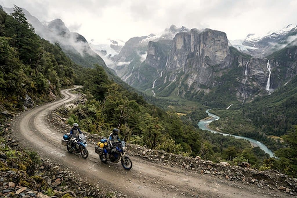
Ruta 40 southbound towards Lago Cardiel
Featured viewpoint
OverviewDay-by-dayBike & gearEssentialsRider notes (1)
arrow_backBack

Route overview

Route overview

Spanning the southern cone from the northern lakes of Bariloche to the legendary End of the World at Bahia Lapataia, the Patagonia Explorer is one of the world's most dramatic dual-sport endeavours.

Riders cross between Argentina and Chile several times, alternating the gravel ribbons of the Carretera Austral (Chilean Route 7) with the unforgiving crosswinds of Argentina's mythical Ruta 40.

storm

Patagonian winds

Crosswind gusts routinely hit 90+ km/h on open pampas. We drill dynamic counter-steering and echelon riding tactics.

support_agent

Dedicated 4x4 support

A Ford F-350 chase vehicle carries fresh knobbies, spare parts, medical gear and luggage throughout.

Route log

Day by day

terrain+18,400 m cumulative · 14.2% steepest

  1. 1

    Bariloche arrival & fleet orientation

    routeBariloche · -

    Fleet handover, ergonomics setup, gravel drills on the lake circuit and gear check.

  2. 2

    Ruta 40 southbound into Chubut & Esquel

    routeBariloche - Esquel · 290 km

    Open pampas, hard crosswinds and the first long ripio stretches of Ruta 40.

  3. 3

    Carretera Austral & Queulat hanging glacier

    routeEsquel - Puyuhuapi · 265 km

    Border crossing at Futaleufú, then deep fjord gravel under the Queulat ice cap.

  4. 4

    Lago General Carrera to Paso Roballos

    routePuyuhuapi - Cochrane · 240 km

    Marble caves, a 1,450 m paso and a long descent into the Cochrane valley.

  5. 5

    Mount Fitz Roy & Perito Moreno ice front

    routeCochrane - El Chaltén · 310 km

    Back into Argentina, glacier viewpoints and the granite spires of Fitz Roy.

  6. 6

    Strait of Magellan ferry & finish in Ushuaia

    routeEl Chaltén - Ushuaia · 420 km

    Punta Delgada RORO crossing, Tierra del Fuego steppe and the finish at Bahia Lapataia.

Field kit

Motorcycle fleet & riding kit

  • two_wheelerBMW R 1250 GS

    Tubeless spoked rims, heavy-duty crash bars, Heidenau K60 Scout knobbies.

  • two_wheelerYamaha Ténéré 700

    Rally-biased off-road setup with long-travel KYB suspension and aluminium skid plate.

  • two_wheelerKTM 890 Adventure R

    WP XPLOR suspension for aggressive gravel, low-slung tanks for stability.

Recommended equipment

  • Tubeless spoked wheels
  • Heated grips
  • Auxiliary lighting
  • 12V USB-C charging

Mandatory rider kit

  • ECE 22.06 helmet
  • Certified back protector
  • Waterproof gloves + liners
  • Sturdy boots

Field dispatches

Rider notes

1 note · Every note is reviewed before publishing.

loginSign in to comment
  • TR

    Test Rider04 Oct 2026

    La traccia GPX è precisa fino all'ultimo waypoint. Consiglio di partire presto per il vento.

Route intel

Route telemetry dispatch

Self-guided

Seasonal windows

  • Nov - JanPrime
  • Feb - MarLate season
  • Apr - OctPasses closed
Border crossings
3 (ARG / CHL)
Ferry booking ahead
Punta Delgada RORO

fact_checkRoute checklist

  • checkChilean SAG customs declaration
  • checkArgentine temporary import permit
  • checkInternational driving permit
  • checkTravel insurance with evacuation
  • checkSpare tubes / tubeless plugs
MotoAtlas

Routes for riders who'd rather take the long way. Surveyed, ridden and written up for touring and dual-sport travel.

  • explore
  • two_wheeler
  • terrain
  • public

Tour categories

  • Alpine high passes
  • Desert & dune crossings
  • Backcountry discovery
  • Coastal fjord traverses
  • Guided dual-sport

Expedition resources

  • Trans-Alpine GPX (demo)
  • Carnet & border crossing prep
  • Technical tire & luggage specs
  • Satellite SOS & wayfinding
  • Safety protocols & evacuation

Waypoint dispatches

New routes, open passes and road intel, once a week.

mail

© 2026 MotoAtlas Expedition Technologies. All rights reserved.

  • Terms of service
  • Privacy policy
  • Route safety disclaimer