Skip to content
MotoAtlasMotoAtlasMotoAtlasMotoAtlas
two_wheelerToursterrainRoutes
routePlan your ridearrow_forwardperson
MotoAtlas

Routes for riders who'd rather take the long way. Surveyed, ridden and written up for touring and dual-sport travel.

  • explore
  • two_wheeler
  • terrain
  • public

Tour categories

  • Alpine high passes
  • Desert & dune crossings
  • Backcountry discovery
  • Coastal fjord traverses
  • Guided dual-sport

Expedition resources

  • Trans-Alpine GPX (demo)
  • Carnet & border crossing prep
  • Technical tire & luggage specs
  • Satellite SOS & wayfinding
  • Safety protocols & evacuation

© 2026 MotoAtlas Expedition Technologies. All rights reserved.

  • Terms of service
  • Privacy policy
  • Route safety disclaimer
Skip to content
MotoAtlasMotoAtlasMotoAtlasMotoAtlas
two_wheelerToursterrainRoutes
routePlan your ridearrow_forwardperson
MotoAtlas

Routes for riders who'd rather take the long way. Surveyed, ridden and written up for touring and dual-sport travel.

  • explore
  • two_wheeler
  • terrain
  • public

Tour categories

  • Alpine high passes
  • Desert & dune crossings
  • Backcountry discovery
  • Coastal fjord traverses
  • Guided dual-sport

Expedition resources

  • Trans-Alpine GPX (demo)
  • Carnet & border crossing prep
  • Technical tire & luggage specs
  • Satellite SOS & wayfinding
  • Safety protocols & evacuation

© 2026 MotoAtlas Expedition Technologies. All rights reserved.

  • Terms of service
  • Privacy policy
  • Route safety disclaimer
Skip to content
MotoAtlasMotoAtlasMotoAtlasMotoAtlas
two_wheelerToursterrainRoutes
routePlan your ridearrow_forwardperson
MotoAtlas

Routes for riders who'd rather take the long way. Surveyed, ridden and written up for touring and dual-sport travel.

  • explore
  • two_wheeler
  • terrain
  • public

Tour categories

  • Alpine high passes
  • Desert & dune crossings
  • Backcountry discovery
  • Coastal fjord traverses
  • Guided dual-sport

Expedition resources

  • Trans-Alpine GPX (demo)
  • Carnet & border crossing prep
  • Technical tire & luggage specs
  • Satellite SOS & wayfinding
  • Safety protocols & evacuation

© 2026 MotoAtlas Expedition Technologies. All rights reserved.

  • Terms of service
  • Privacy policy
  • Route safety disclaimer
Skip to content
MotoAtlasMotoAtlasMotoAtlasMotoAtlas
two_wheelerToursterrainRoutes
routePlan your ridearrow_forwardperson
placeHomechevron_rightTourschevron_rightNorthern Europechevron_rightIceland Highlands
River forwards

Iceland Highlands

Volcanic F-roads

placeNorthern EuropeplaceVolcanic F-roads
routeLogLog this ride

Log this ride

Optional, 280 characters. Only you can read it.

Add a field note on this route to verify the stamp.

pendingGPX in survey
calendar_today

Duration

10 days

9 nights

route

Distance

2,100 km

~210 km/day avg

landscape

Terrain

River forwards

Northern Europe

star

Satisfaction

4.80 / 5

52 rider reviews
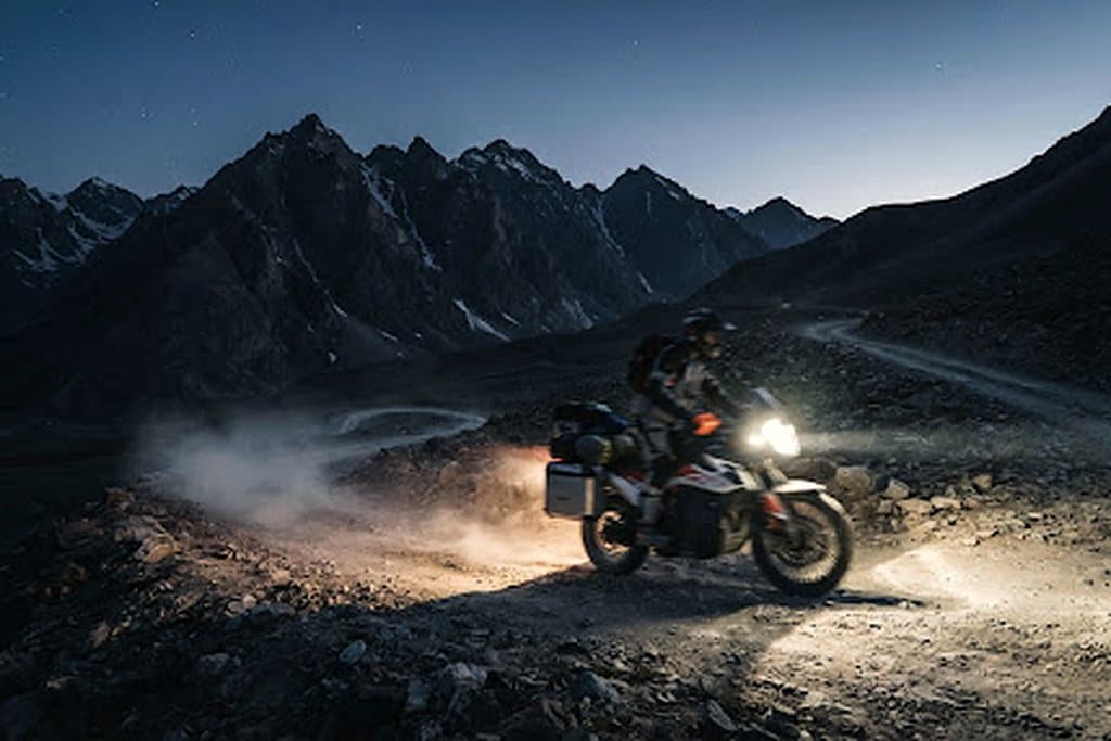
Iceland Highlands approach
Route preview
OverviewDay-by-dayBike & gearEssentialsRider notes
arrow_backBack

Route overview

Route overview

Deep black ash deserts, thermal river crossings and the rugged stone tracks of Sprengisandur.

10 days and 2,100 km of river forwards through Northern Europe, averaging 210 km a day. Fuel gaps, lodging waypoints and evacuation distances are surveyed stage by stage.

sensors

Surveyed telemetry

GPX tracks, fuel gaps and lodging waypoints for all 2,100 km.

health_and_safety

Evacuation cover

Satellite SOS coverage mapped per stage, with nearest clinic distances documented.

Route log

Day by day

terrain+6,300 m cumulative · 11.4% steepest

  1. 1

    Arrival & machine check

    routeNorthern Europe gateway · 420 km

    Fleet handover, luggage fitting and a shakedown loop before the route leaves Northern Europe.

  2. 3

    Opening sector

    routeVolcanic F-roads stage 2 · 420 km

    Roughly 420 km of river forwards, with fuel and lodging waypoints at both ends of the stage.

  3. 6

    Mid-route pass

    routeVolcanic F-roads stage 3 · 420 km

    Roughly 420 km of river forwards, with fuel and lodging waypoints at both ends of the stage.

  4. 8

    Remote refuel & wild camp

    routeVolcanic F-roads stage 4 · 420 km

    Roughly 420 km of river forwards, with fuel and lodging waypoints at both ends of the stage.

  5. 10

    Final approach & finish

    routeVolcanic F-roads stage 5 · 420 km

    Roughly 420 km of river forwards, with fuel and lodging waypoints at both ends of the stage.

Field kit

Motorcycle fleet & riding kit

  • two_wheelerBMW R 1250 GS

    Tubeless spoked rims, heavy-duty crash bars, Heidenau K60 Scout knobbies.

  • two_wheelerYamaha Ténéré 700

    Rally-biased off-road setup with long-travel KYB suspension and aluminium skid plate.

  • two_wheelerKTM 890 Adventure R

    WP XPLOR suspension for aggressive gravel, low-slung tanks for stability.

Recommended equipment

  • Tubeless spoked wheels
  • Heated grips
  • Auxiliary lighting
  • 12V USB-C charging

Mandatory rider kit

  • ECE 22.06 helmet
  • Certified back protector
  • Waterproof gloves + liners
  • Sturdy boots

Field dispatches

Rider notes

0 notes · Every note is reviewed before publishing.

loginSign in to comment

No approved notes on this route yet. Be the first to leave conditions, fuel gaps or a warning.

Route intel

Route telemetry dispatch

Self-guided

Seasonal windows

  • PrimePrime
  • ShoulderShoulder
  • Off seasonClosed

fact_checkRoute checklist

  • checkInternational driving permit
  • checkTravel insurance with evacuation
  • checkOffline GPX plus paper map
  • checkTyre repair kit and spare tubes
  • checkSatellite messenger with tracking
MotoAtlas

Routes for riders who'd rather take the long way. Surveyed, ridden and written up for touring and dual-sport travel.

  • explore
  • two_wheeler
  • terrain
  • public

Tour categories

  • Alpine high passes
  • Desert & dune crossings
  • Backcountry discovery
  • Coastal fjord traverses
  • Guided dual-sport

Expedition resources

  • Trans-Alpine GPX (demo)
  • Carnet & border crossing prep
  • Technical tire & luggage specs
  • Satellite SOS & wayfinding
  • Safety protocols & evacuation

Waypoint dispatches

New routes, open passes and road intel, once a week.

mail

© 2026 MotoAtlas Expedition Technologies. All rights reserved.

  • Terms of service
  • Privacy policy
  • Route safety disclaimer