Skip to content
MotoAtlasMotoAtlasMotoAtlasMotoAtlas
two_wheelerToursterrainRoutes
routePlan your ridearrow_forwardperson
MotoAtlas

Routes for riders who'd rather take the long way. Surveyed, ridden and written up for touring and dual-sport travel.

  • explore
  • two_wheeler
  • terrain
  • public

Tour categories

  • Alpine high passes
  • Desert & dune crossings
  • Backcountry discovery
  • Coastal fjord traverses
  • Guided dual-sport

Expedition resources

  • Trans-Alpine GPX (demo)
  • Carnet & border crossing prep
  • Technical tire & luggage specs
  • Satellite SOS & wayfinding
  • Safety protocols & evacuation

© 2026 MotoAtlas Expedition Technologies. All rights reserved.

  • Terms of service
  • Privacy policy
  • Route safety disclaimer
  • exploreExplore
  • terrainAtlas
  • routePlan
  • personProfile
Skip to content
MotoAtlasMotoAtlasMotoAtlasMotoAtlas
two_wheelerToursterrainRoutes
routePlan your ridearrow_forwardperson
MotoAtlas

Routes for riders who'd rather take the long way. Surveyed, ridden and written up for touring and dual-sport travel.

  • explore
  • two_wheeler
  • terrain
  • public

Tour categories

  • Alpine high passes
  • Desert & dune crossings
  • Backcountry discovery
  • Coastal fjord traverses
  • Guided dual-sport

Expedition resources

  • Trans-Alpine GPX (demo)
  • Carnet & border crossing prep
  • Technical tire & luggage specs
  • Satellite SOS & wayfinding
  • Safety protocols & evacuation

© 2026 MotoAtlas Expedition Technologies. All rights reserved.

  • Terms of service
  • Privacy policy
  • Route safety disclaimer
  • exploreExplore
  • terrainAtlas
  • routePlan
  • personProfile
Skip to content
MotoAtlasMotoAtlasMotoAtlasMotoAtlas
two_wheelerToursterrainRoutes
routePlan your ridearrow_forwardperson
MotoAtlas

Routes for riders who'd rather take the long way. Surveyed, ridden and written up for touring and dual-sport travel.

  • explore
  • two_wheeler
  • terrain
  • public

Tour categories

  • Alpine high passes
  • Desert & dune crossings
  • Backcountry discovery
  • Coastal fjord traverses
  • Guided dual-sport

Expedition resources

  • Trans-Alpine GPX (demo)
  • Carnet & border crossing prep
  • Technical tire & luggage specs
  • Satellite SOS & wayfinding
  • Safety protocols & evacuation

© 2026 MotoAtlas Expedition Technologies. All rights reserved.

  • Terms of service
  • Privacy policy
  • Route safety disclaimer
Skip to content
MotoAtlasMotoAtlasMotoAtlasMotoAtlas
two_wheelerToursterrainRoutes
routePlan your ridearrow_forwardperson
placeHomechevron_rightGearchevron_rightAlpinestars Tech-Air 5 System

Impact protection tech

Alpinestars Tech-Air 5 System

verifiedSafety essentialstar4.95 / 5(210 reviews)

Autonomous wearable airbag vest with six gyroscopic sensors deploying within 20-40 ms before impact.
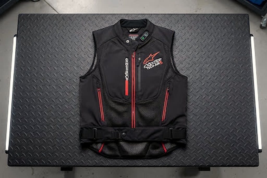
Alpinestars Tech-Air 5 System

fact_checkVerdict

The one piece of kit we will not ride without. No tether, no bike integration, no excuses.

Field notes

Six gyroscopes and accelerometers sample the rider's position continuously; when the algorithm detects a crash signature the airbag inflates in 20-40 ms, before the first impact in most cases.

Because it is autonomous, it works on any bike — including rentals and borrowed machines. That is the entire argument: no tether to forget.

It adds 1.9 kg and needs recharging every 30 hours of riding. In a 10-hour day that is a USB-C cable at lunch, not a problem.

Deployment requires sending the vest to Alpinestars for repacking. Budget for it if you actually crash in it.

check_circleWhat works

  • checkNo tether, no bike integration — works on any machine
  • checkCovers back, chest, shoulders and kidneys
  • checkFits under most adventure jackets
  • checkFirmware updates via app

cancelWhat does not

  • close1.9 kg extra on the torso
  • closeRecharge every ~30 riding hours
  • closeSingle-use after deployment, factory repack required

Specifications

Sensors
6 gyroscopes + accelerometers
Deployment
20-40 ms
Weight
1.9 kg
Battery
~30 h riding
Certification
CE Level 2 back protector
Tested
18 months, 24,000 km

Medical protocols and satellite comms

The field guide behind this review.

Read the guidearrow_forward

One route worth riding, every week

Open passes, fresh tracks and hard-won lessons. No fluff, no spam.

mail

MotoAtlas

Routes for riders who'd rather take the long way. Surveyed, ridden and written up for touring and dual-sport travel.

  • explore
  • two_wheeler
  • terrain
  • public

Tour categories

  • Alpine high passes
  • Desert & dune crossings
  • Backcountry discovery
  • Coastal fjord traverses
  • Guided dual-sport

Expedition resources

  • Trans-Alpine GPX (demo)
  • Carnet & border crossing prep
  • Technical tire & luggage specs
  • Satellite SOS & wayfinding
  • Safety protocols & evacuation

© 2026 MotoAtlas Expedition Technologies. All rights reserved.

  • Terms of service
  • Privacy policy
  • Route safety disclaimer